What is the Largest Volcanic Eruption in Recorded History?

The 1883 eruption of Krakatoa began in May 1883 and culminated with the destruction of Krakatoa on 27 August 1883. Minor seismic activity continued to be reported until February 1884, though reports after October 1883 were later dismissed by Rogier Verbeek's investigation.

| An 1888 lithograph of the eruption | |
| Volcano | Krakatoa |
|---|---|
| Date | 27 August 1883 |
| Type | Plinian |
| Location | 6°06′07″S 105°25′23″E / 6.102°S 105.423°ECoordinates: 6°06′07″S 105°25′23″E / 6.102°S 105.423°E |
| VEI | 6 |
| Impact | Caused 36,417 deaths (possibly more), explosion was heard across the world, caused a volcanic winter that reduced temperatures worldwide by an average of 1.2 degrees Celsius for the next 5 years |
 | |
| A map of Krakatoa after the 1883 eruption, showing the change in geography | |

- Early phase
In the years before the 1883 eruption, seismic activity around the volcano was intense, with some earthquakes felt as far as Australia. Beginning 20 May 1883, three months before the final explosion, steam venting began to occur regularly from Perbuatan, the northernmost of the island's three cones. Eruptions of ash reached an altitude of 6 km (20,000 ft) and explosions could be heard in New Batavia (Jakarta) 160 km (99 mi) away. Activity died down by the end of May, with no records of activity until mid-June.
Eruptions started again around 16 June, when loud explosions were heard and a thick black cloud covered the islands for five days. On 24 June an east wind blew this cloud away and two ash columns were seen issuing from Krakatoa. The new seat of the eruption is believed to have been a new vent or vents which formed between Perbuatan and Danan, near the location of the volcanic cone of Anak Krakatau. The violence of the eruption caused tides in the vicinity to be unusually high, and ships at anchor had to be moored with chains as a result. Earthquake shocks began to be felt at Anyer (Java), and large pumice masses started to be reported by ships in the Indian Ocean to the west.
On 11 August, H.J.G. Ferzenaar investigated the islands. He noted three major ash columns (the newer from Danan), which obscured the western part of the island (the wind blows primarily from the east at this time of year), and steam plumes from at least eleven other vents, mostly between Danan and Rakata. Where he landed, he found an ash layer about 0.5 m (1 ft 8 in) thick; all vegetation had been destroyed, with only tree stumps left. He advised against any further landings. The next day, a ship passing to the north reported a new vent "only a few meters above sea level" (this may be the most northerly spot indicated on Ferzenaar's map). Activity continued through mid August.
Climactic phase
By 25 August, eruptions further intensified. At about 13:00 (local time) on 26 August, the volcano went into its paroxysmal phase, and by 14:00 observers could see a black cloud of ash 27 km (17 mi) high. At this point, the eruption was virtually continuous and explosions could be heard every ten minutes or so. Ships within 20 km (12 mi) of the volcano reported heavy ash fall, with pieces of hot pumice up to 10 cm (3.9 in) in diameter landing on their decks. A small tsunami hit the shores of Java and Sumatra some 40 km (25 mi) away between the time of 18:00 and 19:00 hours.
On 27 August four enormous explosions took place at 05:30, 06:44, 10:02, and 10:41 local time. The explosions were so violent that they were heard 3,500 km (2,200 mi) away in Perth, Western Australia and the Indian Ocean island of Rodrigues near Mauritius, 4,800 km (3,000 mi) away, where they were thought to be cannonfire from a nearby ship. Each was accompanied by very large tsunamis, which are believed to have been over 30 meters (100 ft) high in places. A large area of the Sunda Strait and a number of places on the Sumatran coast were affected by pyroclastic flows from the volcano.
The pressure wave generated by the colossal final explosion radiated from Krakatoa at 1,086 km/h (675 mph). It was so powerful that it ruptured the eardrums of sailors on ships in the Sunda Strait and caused a spike of more than two and half inches of mercury (ca 85 hPa) in pressure gauges attached to gasometers in the Jakarta gasworks, sending them off the scale. The pressure wave radiated across the globe and was recorded on barographs all over the world, which continued to register it up to 5 days after the explosion. Barograph recordings show that the shockwave from the final explosion reverberated around the globe 7 times in total Ash was propelled to a height of 80 km (50 mi).
The eruptions diminished rapidly after that point, and by the morning of August 28 Krakatoa was silent. Small eruptions, mostly of mud, continued through October, though further reports continued through February 1884. These reports were discounted by Verbeek.
- Effects
- Tsunamis and distant effects
A recent documentary film showed tests made by a research team at the University of Kiel, Germany, of pyroclastic flows moving over water. The tests revealed that hot ash travelled over the water on a cloud of superheated steam, continuing to be a pyroclastic flow after crossing water; the heavy matter precipitated out of the flow shortly after initial contact with the water, creating a tsunami due to the precipitate mass.
Smaller waves were recorded on tidal gauges as far away as the English Channel. These occurred too soon to be remnants of the initial tsunamis, and may have been caused by concussive air waves from the eruption. These air waves circled the globe several times and were still detectable using barographs five days later.
- Geographic effects
As a result of the huge amount of material deposited by the volcano, the surrounding ocean floor was drastically altered. It is estimated that as much as 18–21 km3 (4.3–5.0 cu mi) of ignimbrite was deposited over an area of 1,100,000 km2 (420,000 sq mi), largely filling the 30–40 m (98–130 ft) deep basin around the mountain. The land masses of Verlaten and Lang were increased, as was the western part of the remnant of Rakata. Much of this gained material quickly eroded away, but volcanic ash continues to be a significant part of the geological composition of these islands.
Two nearby sandbanks (called Steers and Calmeyer after the two naval officers who investigated them) were built up into islands by ashfall, but the sea later washed them away. Seawater on hot volcanic deposits on Steers and Calmeyer caused steam which some people mistook for continued eruption.
- Global climate
Subsequent volcanism
Anak Krakatau
Verbeek, in his report on the eruption, predicted that any new activity would manifest itself in the region which had been between Perboewatan and Danan. This prediction came true on 29 December 1927, when evidence of a submarine eruption was seen in this area (an earlier event in the same area had been reported in June 1927). A new island volcano, named Anak Krakatau or Child of Krakatoa, rose above the waterline a few days later. The eruptions were initially of pumice and ash, and that island and the two islands that followed were quickly eroded away by the sea. Eventually a fourth island named Anak Krakatau broke water in August 1930 and produced lava flows faster than the waves could erode them. Of considerable interest to volcanologists, this has been the subject of extensive study.

A closer look at Anak Krakatau.
Current activity
Anak Krakatau has grown at an average rate of five inches (13 cm) per week since the 1950s. This equates to an average growth of 6.8 metres per year. The island is still active, with its most recent eruptive episode having begun in 1994. Quiet periods of a few days have alternated with almost continuous Strombolian eruptions since then, with occasional much larger explosions.
The eruption in April 2008 saw hot gases, rocks, and lava released. Scientists monitoring the volcano have warned people to stay out of a 3 km zone around the island. There are several videos of Krakatoa uploaded onto YouTube showing recent footage of it erupting and inside its crater filmed at the edge of the volcano rim.
On 6 May 2009 the Volcanological Survey of Indonesia raised the eruption alert status of Anak Krakatau to Level Orange.
James Reynolds posted footage to YouTube from as recently as November 1, 2010 showing some spectacular eruptions, and NASA has released satellite imagery of the recent activity.
Courtesy : http://en.wikipedia.org/wiki/1883_eruption_of_Krakatoa2. MOUNT TAMBORA (Indonesia)

Mount Tambora (or Tamboro) is an active stratovolcano, also known as a composite volcano, on the island of Sumbawa, Indonesia. Sumbawa is flanked both to the north and south by oceanic crust, and Tambora was formed by the active subduction zone beneath it. This raised Mount Tambora as high as 4,300 m (14,100 ft), making it formerly one of the tallest peaks in the Indonesian archipelago. After a large magma chamber inside the mountain filled over the course of several decades, volcanic activity reached a historic climax in the super-colossal eruption of April 1815.
The 1815 eruption is rated 7 on the Volcanic Explosivity Index, the only such eruption since the Lake Taupo eruption in about 180 AD. With an estimated ejecta volume of 160 cubic kilometers, Tambora's 1815 outburst was the largest volcanic eruption in recorded history. The explosion was heard on Sumatra island (more than 2,000 km (1,200 mi) away). Heavy volcanic ash falls were observed as far away as Borneo, Sulawesi, Java and Maluku islands. Most deaths from the eruption were from starvation and disease, as the eruptive fallout ruined agricultural productivity in the local region. The death toll was at least 71,000 people (the most deadly eruption in recorded history), of whom 11,000–12,000 were killed directly by the eruption; the often-cited figure of 92,000 people killed is believed to be overestimated. The eruption created global climate anomalies that included the phenomenon known as "volcanic winter": 1816 became known as the "Year Without a Summer" because of the effect on North American and European weather. Agricultural crops failed and livestock died in much of the Northern Hemisphere, resulting in the worst famine of the 19th century.
During an excavation in 2004, a team of archaeologists discovered cultural remains buried by the 1815 eruption. They were kept intact beneath the 3 m (9.8 ft) deep pyroclastic deposits. At the site, dubbed the Pompeii of the East, the artifacts were preserved in the positions they had occupied in 1815.
Courtesy : http://en.wikipedia.org/wiki/Mount_Tambora
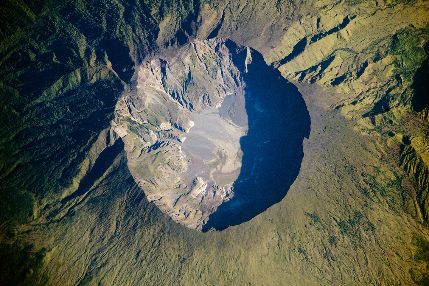
This detailed astronaut photograph depicts the summit caldera of the volcano. The huge caldera—6 kilometers (3.7 miles) in diameter and 1,100 meters (3,609 feet) deep—formed when Tambora’s estimated 4,000-meter- (13,123-foot) high peak was removed, and the magma chamber below emptied during the April 10 eruption. Today the crater floor is occupied by an ephemeral freshwater lake, recent sedimentary deposits, and minor lava flows and domes from the nineteenth and twentieth centuries. Layered tephra deposits are visible along the northwestern crater rim. Active fumaroles, or steam vents, still exist in the caldera.
In 2004, scientists discovered the remains of a village, and two adults buried under approximately 3 meters (nearly 10 feet) of ash in a gully on Tambora’s flank—remnants of the former Kingdom of Tambora preserved by the 1815 eruption that destroyed it. The similarity of the Tambora remains to those associated with the AD 79 eruption of Mount Vesuvius has led to the Tambora site’s description as “the Pompeii of the East.”
Courtesy : http://earthobservatory.nasa.gov/IOTD/view.php?id=394121. MOUNT TOBA SUPERVOLCANO (Indonesia)

About 72,000 years ago a volcanic explosion on the island of Sumatra threw so much ash into the atmosphere that all human life may have been threatened.
Signs of the eruption began when a dark cloud of ash formed over the mountain and the ground started to rumble. Several minor eruptions occurred over several days. Thousands watched the eruption unfold. At 7 PM on 10 April, three columns of flame "rose up and merged" and the mountain was turned into "liquid fire". About 100 km3 (38.6 mi3) of pyroclastic trachyandesite was ejected, enough to qualify as a 7 on the Volcanic Explosivity Index. All vegetation on the island was destroyed. 10,000 people were killed in the pyroclastic flows.
The eruption ejected enough ash into the upper atmosphere to block part of the light from the Sun for months on end. This caused 1816 to be called The Year Without a Summer, in which crops failed worldwide and at least 300,000 people starved or froze. On the plus side, the atmospheric dust from the volcanic explosion caused interesting optical effects, including the most spectacular sunsets in history.
The Year Without a Summer was harsh. Two huge snowstorms hit eastern Canada and New England dead in the middle of June. Nearly a foot of snow fell in Quebec City. As a result, the price of oats and other grains increased by about 700%. The event was called "the last great subsistence crisis in the Western world."
Although the explosion of Mt. Tambora was large, it is not the largest volcanic eruption in all of human history — just recorded history. The largest volcanic eruption in all human history is that of the former Mt. Toba. This was about 28 times larger than the 1815 eruption, and it is believed that the global human population may have been reduced to as few as 1,000 breeding pairs in the aftermath of the event.
The largest volcanic eruption in the history of the Earth were probably the series of eruptions 251 million years ago that created the Siberian Traps, a rock formation in what is now Russia. These eruptions lasted about a million years and released almost enough lava to cover the continent of Australia in a layer 1,000 m deep. This event resulted in the greatest mass extinction in Earth's history, during which 96 percent of all marine species and 70 percent of terrestrial vertebrates were wiped out.
And, this is Lake Toba after The largest volcanic eruption in the history of the Earth!!

Courtesy : http://www.wisegeek.com/what-is-the-largest-volcanic-eruption-in-recorded-history.htm
So, Indonesia is situated in the Pacific Ring of Fire and has around 130 active volcanoes.


No comments:
Post a Comment